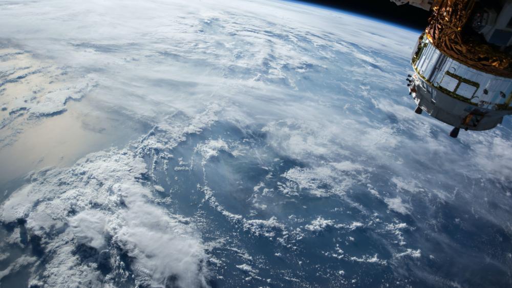
The Earth's surface from the perspective of a satellite. Freshwaters cover only one percent of the surface of our blue planet – making the conservation and exploration of these valuable ecosystems and resources even more important. | Photo: NASA
Rita Adrian | Photo: IGB
Ms Adrian, in one of your studies you used satellite data of 188 of the world's largest lakes, some of which turned out to be more blue, others more green. What is it about these colour differences?
In our research, we used satellite data to estimate the temperature (LST) and chlorophyll-a concentration at the surface of different, large lakes. Chlorophyll is a natural pigment produced by organisms that carry out photosynthesis. In water, these are algae and cyanobacteria, for example. Using the data obtained, we analysed the relationship between lake surface temperature and chlorophyll-a concentration. We found that the directionality of the relationship between the two factors depends on the trophic state of a lake, i.e. the nutrient concentration: in phytoplankton-rich lakes, warming tended to lead to a further increase in chlorophyll-a, whereas in phytoplankton-poor lakes it led to a decrease. Nutrient-limited lakes, which often appear blue in satellite images, are therefore likely to become less productive in the course of global warming. The reason is the warming-induced prolongation of stable thermal stratification. When the nutrients in the upper water layers are depleted, the deep water is often the only remaining source of nutrients. If the lakes mix less, the upper, light-flooded water layers remain separated from this nutrient depot for longer periods of time. The phytoplankton lacks nutrients, the algal biomass decreases – the lakes become even "bluer". In nutrient-rich, "green" lakes it is different: due to stable stratification, they are likely to become more productive - and greener. This phenomenon follows the causal chain for nutrient-rich lakes: higher temperatures lead to longer thermal stratification. This in turn results in a loss of oxygen in the deep water, which favours internal fertilisation from the sediment. This further increases eutrophication and with it the algae biomass, which makes the water appear green from a distance.

Sabine Wollrab | Photo: IGB
Ms Wollrab, you are investigating how river-connected lakes react to nutrient inputs or to extreme weather events - both phenomena that will become more important in the course of climate change. What do satellite images tell you?
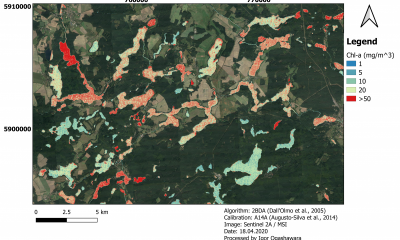
We are observing worldwide how water levels and runoff regimes of freshwater systems are impacted by changes in precipitation and landuse patterns. For example, nutrients that originate from agriculture and are flushed into water bodies by heavy rainfall events accumulate along river systems. They are transported downstream and can cause intense algal blooms. We are interested in the role played by lakes connected with such river systems. There are very few studies on river-connected lake systems and they are largely based on data with low temporal and spatial resolution. This is where satellite images come into play, because every two to three days the Sentinel-2 satellites fly over our study area in the North German Lowlands. Thanks to the high spatial and temporal resolution, we can observe how algal blooms develop and distribute there in a regional context. We can see, for example, that upstream nutrient inputs lead to an increased development of phytoplankton downstream. How intense this algal bloom is and how far and fast it spreads along river-connected lake chains depends on the flow regime and the lake characteristics, i.e. their volume and depth, which determine the residence time of the water.
Stella Berger | Photo: IGB
Ms Berger, as an expert working with phytoplankton, you lead the CONNECT project already referred to above. How is it possible to draw concrete conclusions from remote sensing data on algal blooms and their development?
Thanks to new technologies, such as the use of multi- or hyperspectral cameras on satellites or drones, we can estimate the chlorophyll-a content of water bodies over large areas and thus obtain information about the spatial distribution of phytoplankton biomass in lakes. Especially for connected lakes, comparing these remote sensing images over time helps to track the signal transport of chlorophyll-a along river-connected lake chains. In order to use chlorophyll-a data from remote sensing, bio-optical modeling must be adapted for relatively small water bodies because of the influence of the surrounding environment (forest, meadow, field, buildings, etc.), the bottom of the water body (sediment characteristics, macrophyte population, etc.), and nutrient levels. This includes coordinated sampling and laboratory analysis of chlorophyll-a content in combination with in-situ monitoring data from automatised multiparameter probes to match remote sensing data – also called "ground-truthing". Together, they provide a solid framework for early detection of potential algal blooms and their spread. In the field as well as in large-scale experiments at the IGB-LakeLab, we could show that the Chlorophyll-a content from remote sensing data in the upper water layer was well mapped with appropriately adapted models and algorithms. However, algae in deeper water layers, which form a so-called deep chlorophyll maximum, cannot be detected by current remote sensing technology. Our research also aims to obtain even more detailed information about the composition of phytoplankton. In addition to chlorophyll-a, we would like to use other alage pigments as indicators of blue-green algal blooms. In combination with multiparameter networks, targeted sampling and image-based plankton analysis, remote sensing can contribute to better differentiation of different algal groups in the future and thus help early detection of potentially toxic phytoplankton blooms.

Jens Nejstgaard | Photo: IGB
Mr Jens Nejstgaard, what other methods are helpful or even necessary to match data from satellites or drones with the actual state of the water bodies?
The possibilities of artificial intelligence and imaging technologies in particular have developed rapidly over the last two decades. Whereas it used to take experts hours or even days to analyse a single preserved sample of organisms in the laboratory, new automatic video techniques allow us to observe living organisms directly in their complex ecosystems in minutes. To explore this opportunity, research groups at IGB and around the world are developing such automated systems. They will fundamentally change the way we observe what is going on in all kinds of water bodies. In freshwater as well as marine research, combining in-situ probe measurements and image-based technologies is very likely to become a important tool, allowing precice real-time data to be linked with remote sensing data and used for predictions. To advance the development of such effective ground-truthing of remote sensing approaches, we have been using the IGB LakeLab in Lake Stechlin together with many international colleagues. The first results of this collaboration, initiated within the EU-H2020 project AQUACOSM, which we coordinate, supports our hypothesis: Combining these techniques has great potential to extend our abilities to observe and understand our environment in time and space – especially when carefully calibrated, as we do in our mesocosm experiments.
Igor Ogashawara | Photo: private
Mr Ogashawara, you dedicate yourself to sensors on satellites so that images can be better used for water monitoring in the future. Where are the biggest technical hurdles and what developments can we expect?
As my colleagues have already mentioned, the use of remote sensing technology for water monitoring has enormous potential, especially due to the launch of new satellite sensors which are used to assess water quality and quantity. But satellite imagery also poses challenges. For example, there is a lack of an efficient way to reduce atmospheric effects in the image data. Atmospheric correction is particularly challenging for inland waters because the optical signal in the water column and also in the surrounding areas of the aquatic system is complex. Luckily, there are efforts in the scientific community to tackle this issue and define standards – for example, within the GEO AquaWatch network. Just recently, we have released a product family specification for the aquatic reflectance product published by the Committee on Earth Observation Satellites (CEOS). This document specifies the requirements for the atmospheric correction processors to retrieve the aquatic reflectance from satellite imagery. Another challenge is the lack of match-up data, which is essential for Earth observation calibration and validation activities. This is why the collaboration between limnology and remote sensing communities is so promising for the development of new products. We are also hopeful that remote sensing technology is constantly evolving: New hyperspectral satellite sensors – as in the German EnMAP mission (Environmental Mapping and Analysis Program) launched in April – will enable us to monitor even more water quality variables from space. Emerging issues and developments are being discussed within the framework of the H2020 project Water-ForCE, from which a roadmap for the future development of water products for Copernicus will emerge. So we can expect to have new, harmonised and better validated remote sensing-based products for monitoring water systems in the near future.
Andreas Jechow | Photo: private
Mr Jechow, not only daytime images are relevant. You are more interested in the night side of the globe and encounter a completely different ecological problem. Which one?
We are indeed interested in the night and especially in artificial light. Too much artificial light causes so-called light pollution and disturbs nocturnal animals in particular, but also has an impact on plants and can upset entire nocturnal ecosystems. Earth observation satellites and measurements from aircraft or drones help us quantify the extent of light pollution. At night, human traces on the Earth become particularly easy to see. Many are certainly familiar with the spectacular images of the Earth at night. Generally speaking, where there are people, there is light. Since humans often settle close to water bodies, aquatic ecosystems are more affected by light pollution than terrestrial ones. Night has not been studied as intensively as day for a long time, even though half of the globe is immersed in night at any given time. Unfortunately, satellite systems that operate at night are not nearly as sophisticated as Earth observation systems that operate during the day. In principle, there is only one satellite that provides daily information of the entire Earth and this only monochromatically in the visible spectral range and with a coarse spatial resolution of 750m. With this data set, IGB researchers together with an international team were able to show that light pollution is increasing exponentially at more than 2 per cent per year. High-resolution multispectral data are only available sporadically, for example from some cities recorded by the International Space Station (ISS). These require considerable effort in the post-processing of the data. It would be desirable to have a mature multispectral satellite system that reliably delivers high-resolution and freely available data of the entire Earth, even at night.

Hauke Dämpfling | Photo: private
Mr Dämpfling, you support researchers in remote sensing with drones. What benefits do they provide and what about the accessibility of the data, also for third parties?
Drones or “unmanned aerial systems” (UAS) are an important part of the spectrum of remote sensing solutions. While some satellites need several days cover the entire earth’s surface, drones are much more flexible in terms of location and time. For example, they can be used directly after events of interest such as strong rains. Relative to satellites and airplanes, drones can only cover a small area per day, but they can do so at much higher resolution, often better than centimeter accuracy. Also, unfortunately, some satellite data is only available at a cost, so drones can be a fairly inexpensive alternative. One challenge when handling drone data is that it is easy to produce large data sets, which then need to be stored and processed as “big data” with appropriate computer systems and software. At the IGB we strive to make more and more of our research data public according to the “F.A.I.R.” principles, so that other researchers can reuse this data. Also, we believe it is important for the general public to get a deeper view into our research, since much of the research is publicly funded. The preparation of measurement data for such a publication requires a significant organizational effort, which we would like to centrally support in the near future. So the actual flying of the drone turns out to only be a small part of the measurement process chain.

Hans-Peter Grossart | Photo: IGB
Mr Grossart, let‘s broaden the perspective at the end. The Leibniz research network "Integrated Earth System Research" (iESF), in which IGB is also involved, focuses on the Earth system as a whole. What insights do you expect to gain from this?
Within the Leibniz Research Network we aim to better understand the full breadth of the dramatic global changes resulting from the increase in human activities during the Anthropocene. That is why we are striving for a holistic Earth system approach. A solid knowledge of the causes of the most pressing, often human-induced, global problems such as biodiversity loss, resource depletion, global warming, and water availability requires a holistic view that also takes into account current socio-economic changes. By looking at a wide variety of Earth system components in their diverse interactions, the network can also gain insights into indirect effects as well as complex feedback mechanisms of human actions. The hydrological cycle in particular is a good example, as it clearly reflects the multiple changes and feedback effects on a wide range of spatial and temporal scales. Thus, short-term extreme events such as droughts or floods as well as long-term climate changes, e.g. global warming, lead to major changes in future availability of clean drinking water or sufficient water for agriculture and industry, which has a massive and lasting impact on our societies. These findings will be incorporated into a wide variety of modeling approaches in order to better assess the global consequences of human actions. In particular, by including socio-economic factors at the Earth system level, potential consequences for different human societies on Earth will be identified. This should make it possible to rapidly develop options for action so that diverse societies can effectively adapt to the challenges of future Earth system changes in a variety of ways.
Performance of the Landsat 8 Provisional Aquatic Reflectance product for inland waters
Reconciling the opposing effects of warming on phytoplankton biomass in 188 large lakes
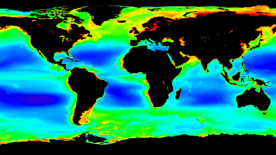
Satellite image showing a global Chlorophyll-a map that researchers use for their analyses. Blue and green indicate a low, red a high phytoplankton biomass. | Image: Map freely available for reuse / NASA's OceanColor Web
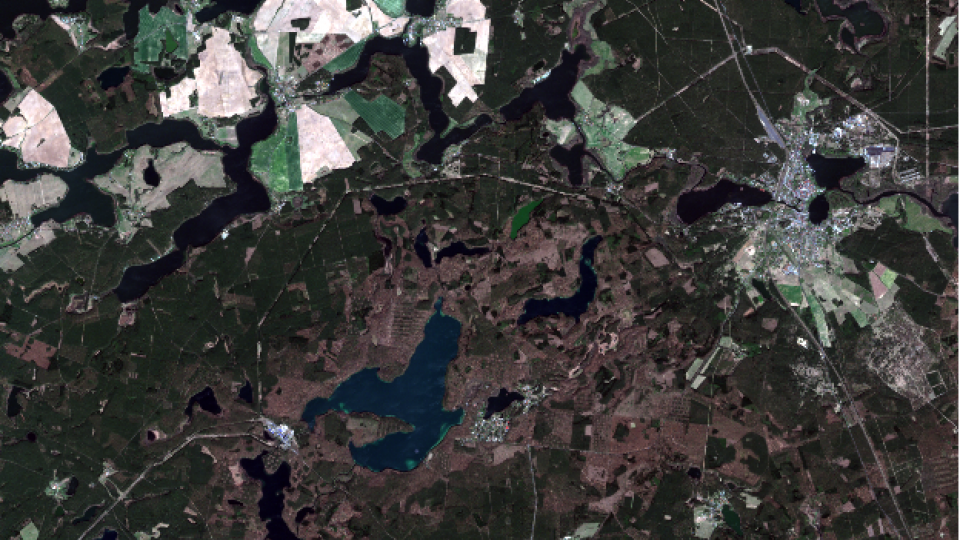
Lake Stechlin view from the Sentinel-2 Multispectral Instrument (MSI) on 21 April 2020.
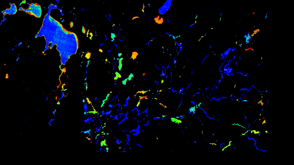
Satellite image of lakes in the North German Lowlands, as used by IGB researchers in the CONNECT project to determine the chlorophyll-a concentration in the water. | Image: Sentinel-2A