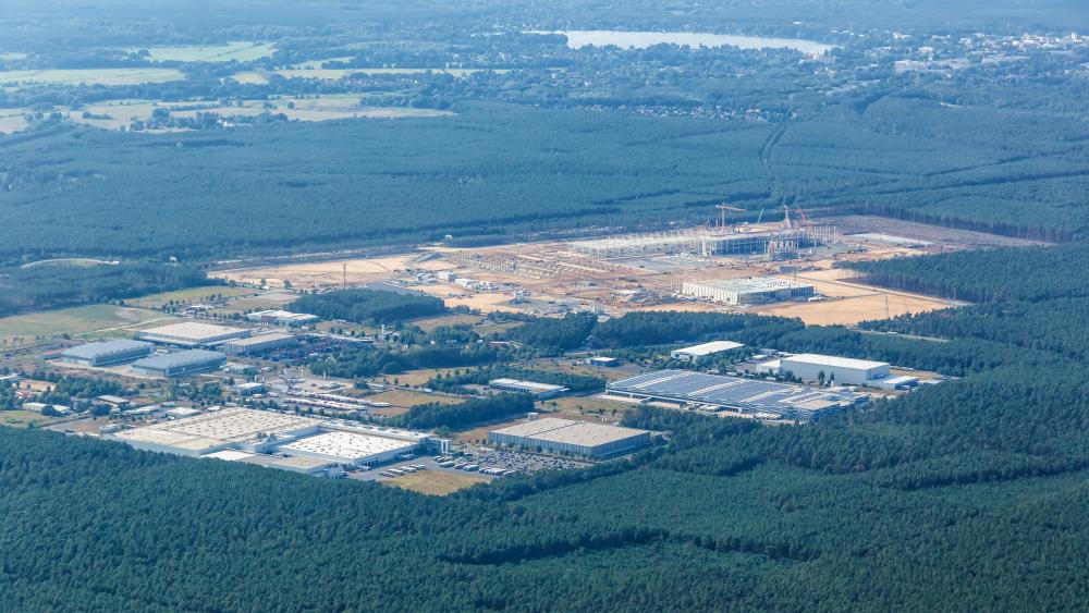
The site of the future Tesla Gigafactory in Grünheide in August 2020. | Photo: Markus Mainka / Shutterstock.com
Having been formed during the Ice Age, the landscape of the Berlin-Brandenburg region is very water-scarce, despite its abundance of water bodies. This is a significant and important difference: although a comparatively large number of surface water bodies are visible in Berlin-Brandenburg (Fig. 1), the region is one of the areas with the lowest rainfall in Germany [DWD 2019]. Despite the fact that three rivers – the Spree, the Dahme and the Havel – flow through Berlin, they carry little water compared to other major rivers in Germany. As a result, relatively little water is available for the ecosystems as well as the various water uses. The pressure of use is already comparatively high in the Spree catchment area.
Apart from the amount of available water (quantity), its condition (quality) also plays a crucial role. Both aspects – and how they interact – must be considered in equal measure when assessing water use.
From a water management perspective, commercial, public and private development projects affect water demand, water abstraction and water treatment, as well as wastewater flow, wastewater treatment and the discharge of treated wastewater. The effects in each of the aforementioned areas can influence or restrict the public conservation objectives (in accordance with Section 6 of the Federal Water Act (WHG)) for water bodies (e.g. the good ecological status of water bodies) as well as other uses (e.g. drinking water abstraction, fisheries or recreational uses such as watersports). These individual aspects are discussed in greater detail below.
Assessing long-term consequences, making data bases public, and weighing up conflicting goals
Besides providing valuable habitat, groundwater and surface waters are also important resources. This repeatedly leads to conflicting goals between the protection and use of these ecosystems, as well as between different competing uses. Based on IGB’s scientific evaluation, it is therefore all the more important to have a precise knowledge of the impact of existing and planned uses on the conservation objectives set out in legislation. This enables the assessment of the overall effect on the water system and is especially crucial in water-scarce regions such as the Spree catchment and the Greater Berlin area. For such an analysis, it is appropriate to consider the many different ecosystem services¹ that freshwater ecosystems provide. It is also necessary to assess which interventions or actions will change these services, and in what way. Decisions in permit procedures should be made transparently and on the basis of the best possible technical expertise and reliable data from ecohydrology and freshwater ecology. The threat to protected areas, species and aquatic ecosystems in general should be kept to a minimum in accordance with legal requirements (e.g. the Federal Water Act (WHG), the Water Framework Directive (WFD), and the Habitats Directive (HD)). It is only legally permissible to compromise the status of surface waters and groundwater bodies in very limited exceptional cases.
In the case of large-scale projects, the decision-making basis and data should always be publicly accessible, given their high social relevance. This enables various stakeholders to conduct independent analyses. Ecohydrological, limnological, chemical and biological data should be used to weigh up decisions related to drinking water and groundwater protection, and sensitive habitats. Such data and models, e.g. on the flow behaviour of surface waters and groundwater under certain conditions and scenarios, should be integrated into the long-term risk assessment with a level of quality commensurate with the complex issue at hand. In the process, the water quantity and quality values observed in the past cannot be assumed to hold for the future without further consideration. After all, the expected effects of climate change in the post-mining landscape must be taken into account. In the absence of such data and information, or where it is of insufficient quality, it should be collected on behalf of the public in accordance with scientific quality standards, and made publicly available.
An explanation is given below of fundamental aspects concerning water and freshwater ecosystems that require urgent consideration when siting industrial projects in the Berlin-Brandenburg region. The current situation, water quantity and quality predictions, and water management aspects have already been explained in detail in the Brandenburg Climate Report of the Deutscher Wetterdienst [DWD 2019], the Low Water Report of the Senate Department for the Environment, Transport and Climate Protection [SenUVK 2021a], and the Low Water Concept of the Ministry of Agriculture, Environment and Climate Protection [MLUK 2021]. The SenUVK is currently developing a Water Master Plan, which should contain measures and strategies to meet both current and future challenges [SenUVK 2021b].
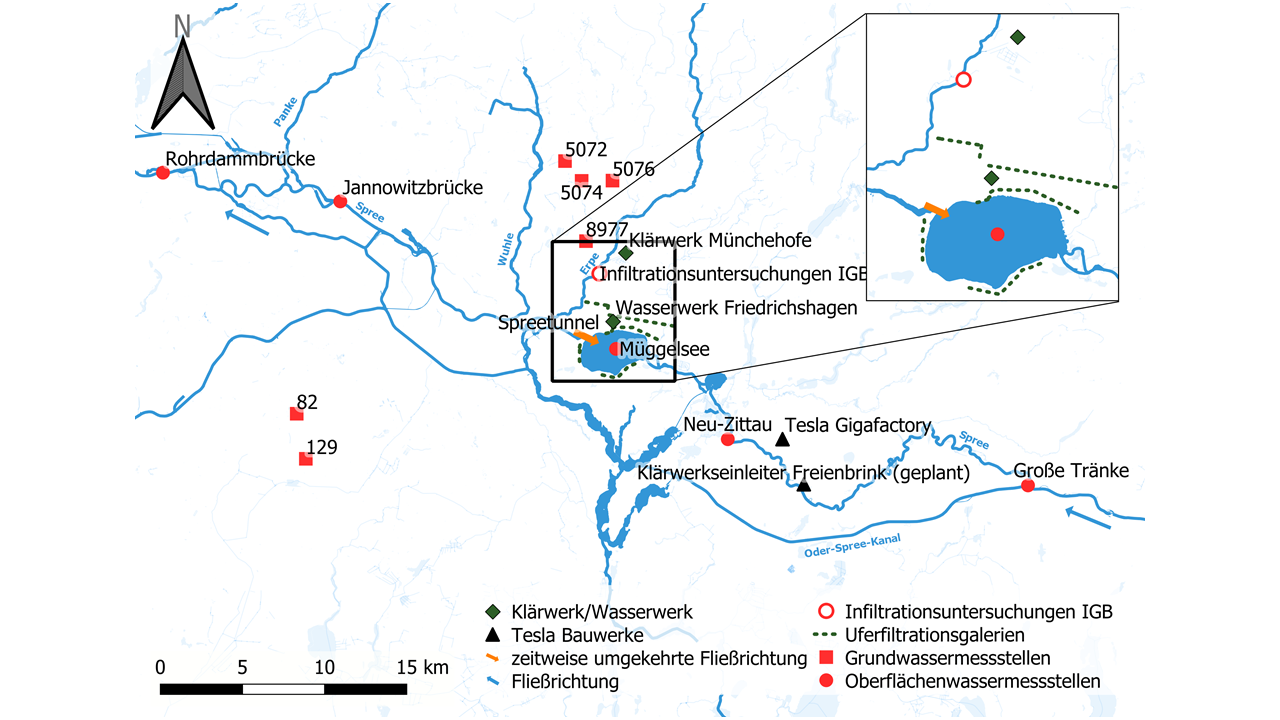
Fig. 1: Overview map of water bodies, sampling points, and water supply and wastewater disposal infrastructure. | Figure: Anna Lena Kronsbein/IGB
Water scarcity and a growing demand for water in the region
Despite having an abundance of water bodies, Berlin-Brandenburg is one of the most water-scarce regions in Germany, with low rainfall levels [DWD 2019]. The region contains rather limited near-surface freshwater aquifers, with saltwater aquifers predominating from a depth of about 300 metres [TU Berlin 2020].
The annual mean temperature and the number of summer days (with a maximum temperature of at least 25°C) can be expected to increase as a result of climate change. No significant increase in annual precipitation is expected between now and 2050. However, precipitation rates will be distributed differently throughout the year: while there will be less rain in the summer months, precipitation will increase in spring and winter. In addition, local heavy rainfall events will occur more frequently. In general, climate change will lead to a clustering of extreme weather events such as prolonged drought, further exacerbating the already critical situation of regional water availability [DWD 2019].
Higher temperatures lead to an increase in evaporation from water surfaces, from soils and by plants (evapotranspiration). This phenomenon not only reduces the amount of water available, but also has a negative impact on water quality and ecosystems [DWD 2019, SenUVK 2021a]. The recent drought in the Berlin-Brandenburg region (2018) showed just how vulnerable hydrographic networks are to reduced precipitation due to temporary desiccation, and highlighted the importance of having vegetation and different forms of land use in the regional context [Kleine et al. 2021].
Prolonged dry spells lead to a deterioration of the water holding capacity of soils, which in turn affects the groundwater recharge rate [DWD 2019]. A change in precipitation patterns towards more heavy rainfall events in the wake of climate change would also lead to lower groundwater recharge because, instead of infiltrating into the ground, more water from the area would run off the surface or evaporate.
Based on current climate forecasts, local storm water leaching is therefore necessary for all sealed surfaces. According to Section 3.2 of the Environmental Impact Assessment (EIA) for Tesla’s construction project, there are plans to ensure storm water leaching. To this end, the Brandenburg State Office for the Environment (LfU) issued a permit on 13 September 2021 for the early start of the construction of stormwater infiltration systems [LfU 2021]. Since undesirable substances may be mobilised and transported from sealed surfaces by precipitation water, however, the quality of the precipitation runoff should be tested regularly, which, according to the EIA documents, is also intended [LfU 2021]. It may be the case that pre-treatment, e.g. using filter systems, is required prior to infiltration so as to intercept undesirable substances and prevent the contamination of adjacent ecosystems and groundwater.
Groundwater recharge data from the past 30 years already show a predominantly negative trend [DWD 2019]. Figure 2 shows examples of declining groundwater levels in the region. Besides causing a reduction in the quantity of water in surface waters, declining groundwater levels are also problematic for groundwater-dependent ecosystems such as peatlands [Klingenfuß et al. 2015], forests and urban trees, as well as water management facilities [SenUVK 2021a]. Seen from a historical perspective, landscape drainage (drainage, river regulation, draining of peatlands) initially promoted the agricultural use of land in the region [Nützmann et al. 2011]. However, climate change and the demand for water by humans and nature necessitate a rethink towards a near-natural water balance with long retention times in the region through increased water retention.
Another challenge is the increasing demand for water in the region. Berlin’s continuing population growth results in a greater demand for water and new areas of land being sealed. The increasing development of the “stockbroker belt” also results in additional land sealing, which in turn reduces groundwater recharge and water retention in the landscape. The trend towards owning a home in the countryside is driving the demand for private garden irrigation. As a result of climate change, there is also a growing need for irrigation of inner-city green spaces and gardens, and of agricultural land. Tesla’s Gigafactory will be an additional user: the factory’s water requirements are specified as 1.4 million cubic metres per year in the current EIA documents [LfU 2021]. This equates to the water demand of a town with 31,000 inhabitants.
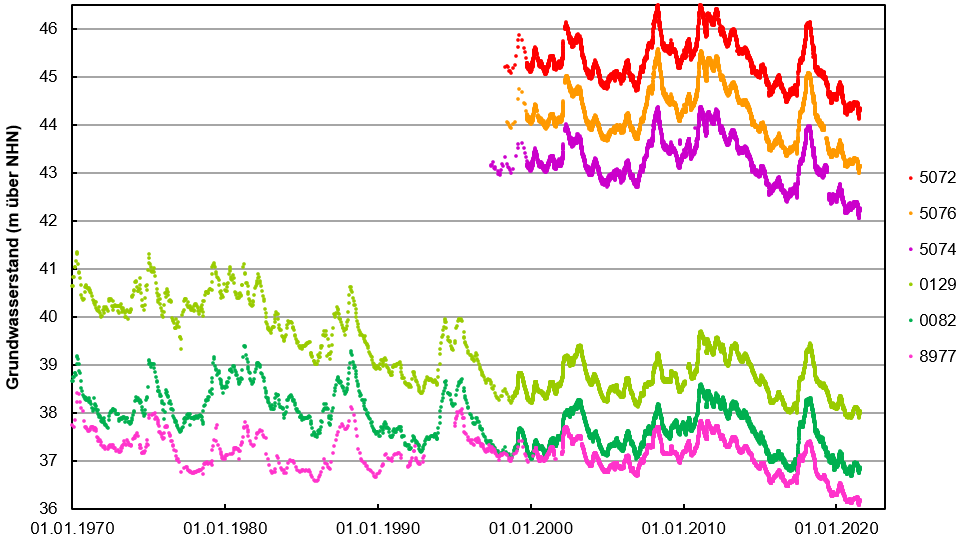
Fig. 2: Declining groundwater levels at monitoring points of the Berlin Senate. All monitoring points are located on the Barnim Plateau (red shades) or the Teltow Plateau (green shades); the exact location is shown in Fig. 1. | Figure: Jörg Lewandowski/IGB based on data provided by the Federal State of Berlin
Increasing contamination from trace organic compounds
Trace organic compounds are chemical compounds produced by humans. They are contained in products such as pharmaceuticals, detergents, pesticides, anti-corrosion agents, paints and lacquers. Trace organic compounds are often very persistent and present in low concentrations in surface waters, groundwater and drinking water. Even low concentrations of some trace substances can have potentially negative impacts on ecosystems or human health. Many of these substances are water-soluble, and can only be broken down partially, or not at all, in wastewater treatment plants. As a result, they are discharged into freshwater ecosystems via wastewater treatment plants, as well as via other sources such as rainwater runoff. From as early as 2009, IGB has measured considerable levels of contamination of the surface water with trace organic compounds in the Erpe, a tributary of the Spree River into which the Münchehofe wastewater treatment plant drains (Fig. 3). Consequently, the authorisation of additional discharges from industrial projects such as the Tesla Gigafactory should be examined very closely, because they could lead to an increase in pollutant loads. This is particularly important in the capital region because groundwater and surface waters are the basis for drinking water supplies. Around 60% of Berlin’s drinking water is obtained via bank filtration, which is surface water that undergoes months of natural purification underground before being extracted. A further 10% is from groundwater recharge, which also comes from surface waters [SenUVK 2021b].
Berlin’s water supply and wastewater disposal system is based on a partially closed water cycle. As a result, the city’s drinking water resources are potentially vulnerable to persistent contaminants because a proportion of treated wastewater is extracted downstream again as drinking water. A yet unpublished study by IGB conducted on the Erpe River east of Berlin below the final effluent discharge point of Münchehofe wastewater treatment plant (“Infiltration studies IGB” in Fig. 1) showed that trace substances from the Erpe are discharged into the aquifer close to the river and then transported towards a battery of wells belonging to Berliner Wasserbetriebe (BWB). Investigations by BWB indicated that trace substances are already present in these drinking water wells (northernmost bank filtration gallery in Fig. 1) [BWB, personal communication with Uwe Dünnbier, 14 June 2021]. This example shows that drinking water in the Greater Berlin area could be more heavily contaminated with trace organic compounds in the future. For this reason, new major sources of contamination should be avoided wherever possible.
![Abb. 3: Konzentration ausgewählter Spurenstoffe in der Erpe unterhalb der Einleitung des Klärwerks Münchehofe zwischen 2009 und 2019. | Datenquellen: Juli 2009: Lewandowski et al. [2009], Dezember 2015: Schaper et al. [2018], Juli 2016: Schaper et al. [2019], September 2018: Mueller et al. [2021], Juli 2019: Unveröffentlichte Daten von Hanna Schulz. Angegeben ist der Median der Konzentrationen in den genommenen Proben, Fehlerbalken zeigen den Interquartilsabstand (2009: Eine Mischprobe, daher kein Interquartilsabstand) | Abbildung: Christoph Josef Reith/IGB](https://www.igb-berlin.de/sites/default/files/media-images/inline-images/Graph_concentrations%20TrOCs_Erpe.png)
Fig. 3: The concentration of selected trace compounds in the Erpe downstream of the discharge of Münchehofe wastewater treatment plant between 2009 and 2019. | Data sources: July 2009: Lewandowski et al. [2009], December 2015: Schaper et al. [2018], June 2016: Jaeger et al. [2019], September 2018: Mueller et al. [2021], July 2019: unpublished data from Hanna Schulz. The median of concentrations from the samples taken is given, error bars show the interquartile range (2009: composite sample, hence no interquartile range). | Figure: Christoph Josef Reith/IGB
The predicted longer dry spells, enhanced evapotranspiration and a higher demand for water may also result in an increased reversal of the flow direction of the Spree and, in the long term, a higher pollutant load of the Müggelsee, and therefore also of the adjacent bank filtration wells for drinking water production [SenUVK 2021b]. This is because in the case of prolonged drought, such as in summer 2019, the Stadtspree, which is already exposed to treated wastewater from the Erpe and Panke, flows back into the Müggelsee against its normal direction of flow (arrow next to Spree tunnel in Fig. 1). Various scenarios on climate change, population development and construction measures were considered in the Water Master Plan. In the future, the Spree will increasingly flow backwards for an average of 3 to 6 months per year, depending on the scenario [SenUVK 2021b]. This could exacerbate existing risks to drinking water quality, which would likewise necessitate a particularly careful examination of the potential additional discharge of pollutants, e.g. from industrial plants.
According to the relevant tender documents, wastewater from the Tesla Gigafactory is to be discharged into the Müggelspree via a newly planned municipal wastewater treatment plant in Freienbrink [WSE 2021]. This discharge could result in a permanently elevated contamination of the Müggelsee and the surrounding bank filtration wells with trace organic compounds, since the lake is downstream from the proposed discharge point. This would further exacerbate the existing problems outlined above.
The extent of contamination will essentially be heavily dependent on the substances used in the production process, the purification technology in the Tesla Gigafactory’s in-house wastewater treatment plant, and the equipment and management of the municipal wastewater treatment plant in Freienbrink, which is yet to be built. In any case, it will not be possible to completely eliminate undesirable substances from the water even with a fourth treatment stage (usually activated carbon or ozonation). Emission prevention should therefore generally be applied in accordance with the polluter-pays principle.
Additional pollutant loads: sulphate in freshwater ecosystems and drinking water
Tesla also requests the discharge of sulphate (SO42-) via wastewater (effluent standard < 600 mg/L, Section 10.7 of the EIA documents [LfU 2021]), which could further increase sulphate levels in the Spree and Müggelsee. Sulphate concentrations in the Spree are already high, which particularly results from active and abandoned opencast lignite mines in the Spree catchment area. IGB’s long-term sulphate monitoring along the Spree shows that sulphate levels in the surface water of the Spree have been very high for years, often reaching the drinking water threshold of 250 mg/L (Fig. 4) [IGB 2016]. For this reason, any additional contamination of the Spree with sulphate should be avoided.
![Abb. 4: Sulfatkonzentration [mg/L] im Oberflächenwasser der Spree von Ost nach West in dem Zeitraum 2010-2020, nicht an allen Standorten liegen für jedes Jahr Daten zur Sulfatkonzentration vor; rot gestrichelte Linie: Trinkwassergrenzwert, Fehlerbalken: Standardabweichung [mg/L], ohne Fehlerbalken: nur ein bis zwei Messwerte verfügbar. | Abbildung: Anna Lena Kronsbein/IGB](https://www.igb-berlin.de/sites/default/files/media-images/inline-images/Sulfatabbildung_16_9.png)
Fig. 4: Sulphate concentration [mg/L] in surface water of the Spree from east to west (Große Tränke-Müggelsee) in the period 2010-2020, data on sulphate levels are not available for every year at all sites; red dotted line: drinking water threshold value, error bars: standard deviation [mg/L], without error bars: only one or two measured values available. | Figure: Anna Lena Kronsbein/IGB
Summary and conclusion
Drawing on many years of research in the Spree catchment, IGB emphasises how important it is to closely examine existing and future exploitation interests, since water and freshwater bodies in the region are already heavily burdened resources and ecosystems.
In the case of large-scale projects, the decision-making basis and data should always be publicly accessible, given their high social relevance. This enables various stakeholders to conduct independent analyses. Decisions in permit procedures should be made transparently and on the basis of the best possible technical expertise and reliable data from ecohydrology and freshwater ecology. The threat to protected areas, species and aquatic ecosystems in general should be kept to a minimum in accordance with legal requirements (e.g. the Federal Water Act (WHG), the Water Framework Directive (WFD), and the Habitats Directive (HD)).
Such close scrutiny is important because the siting of large-scale industrial projects can further exacerbate the already critical water availability and aquatic pollution in regions like Berlin-Brandenburg where water and precipitation are scarce. The effects of climate change, such as temperature increases, heavy rainfall events and prolonged dry spells, combined with a simultaneous increase in water demand, require measures that promote a near-natural water balance with long retention times in the landscape, rather than restricting it even further.
To assess the specific risks to freshwater ecosystems and the ecosystem services they provide (drinking water, irrigation, fisheries, tourism and recreational use, etc.), permit procedures must include a fundamental assessment of water availability and public, commercial and private water demand – not only as an annual average, but also specifically for the critical summer months.
In view of the regional problems described above, when it comes to major industrial sites, care should be taken not only to ensure that applicable environmental legislation is complied with, but also that companies’ management of their water demand, wastewater and precipitation water contributes to a climate-adapted regional water balance, rather than further exacerbating aquatic pollution. To achieve this, environmental and economic policy should be much better interlinked. As a matter of principle, water and freshwater ecosystems should also be taken into account in economic policy decisions across ministries as important, sensitive and limited resources.
For this reason, IGB endorses the principles formulated in the draft National Water Strategy of the Federal Ministry for the Environment [BMU 2021] that companies should be held responsible for aquatic pollution and the substances and products they emit over the entire life cycle, and should pay an appropriate price for the use of water and freshwater ecosystems accordingly. The ultimate goal should be to achieve water-saving production with largely closed water cycles that automatically prevent substances from being emitted into freshwaters. State-of-the-art wastewater treatment technologies should be implemented and continuously updated.
From a scientific perspective, it is essential to have climate-adapted water resource management that accommodates both (drinking) water protection and the needs of different user groups as sustainably as possible, and that also sets clear priorities for situations of scarcity.
For the sake of context: The role of IGB as a public research institute – creating new knowledge, advising the public objectively
IGB is a public non-university research institute that conducts basic research in aquatic ecology, and also integrates application issues into its scientific work. If IGB has decision-relevant research data, the institute is gladly willing to make such data available to other stakeholders who wish to contribute to environmental impact assessments and decision processes. However, drawing up targeted expert opinions, such as in the context of the environmental impact assessment of construction projects, is not among the institute’s core tasks.
As a research institute, IGB always attaches particular importance to the reliability and scientific robustness of its assessments. Therefore, IGB does not make any statements on specific individual cases, unless the institute has its own data base that allows it to make concrete statements accordingly, or if there is a lack of accessible data that meet research quality criteria. The institute itself is not an environmental policy actor, but provides objective advice to politicians, authorities, business and civil society on the basis of its own scientific findings and the current state of the relevant fields of research.
~~~
Authors of the scientific assessment
Tobias Goldhammer, Anja Höhne, Lukas Kleine, Anna Lena Kronsbein, Jörg Lewandowski, Thomas Mehner, Birgit Maria Müller, Martin Pusch, Christoph Josef Reith, Hanna Schulz, Stephanie Spahr
Editors
Johannes Graupner and Angelina Tittmann
Foodnotes
¹ Ecosystem services are services provided by nature for humans; for an explanation in the context of water bodies, see e.g. https://www.resi-project.info/warum-oekosystemleistungen-hintergrund/ and https://www.umweltbundesamt.de/leistungen-nutzen-renaturierter-fluesse#okosystemleistungen-von-fliessgewassern.
References
Bundesministerium für Umwelt, Naturschutz und nukleare Sicherheit BMU (2021). Nationale Wasserstrategie - Entwurf des Bundesumweltministeriums. 76 S. https://www.bmu.de/fileadmin/Daten_BMU/Download_PDF/Binnengewaesser/langfassung_wasserstrategie_bf.pdf, last access 18.08.2021
Deutscher Wetterdienst DWD (2019). Klimareport Brandenburg. 40 S. https://www.dwd.de/DE/leistungen/klimareport_bb/klimareport_bb_2019_download.pdf;jsessionid=F72910E5D1C8D6D896784A34804ABF43.live11042?__blob=publicationFile&v=5, last access 18.08.2021
IGB (2016). Dossier: Sulfatbelastung der Spree - Ursachen, Wirkungen und aktuelle Erkenntnisse. 13 S. https://www.igb-berlin.de/sites/default/files/media-files/download-files/IGB_Dossier_2016_Sulfat_END.pdf, last access 18.08.2021
Jaeger, A., Posselt, M., Betterle, A., Schaper, J., Mechelke, J., Coll, C., & Lewandowski, J. (2019). Spatial and temporal variability in attenuation of polar organic micropollutants in an urban lowland stream. Environmental Science & Technology, 53(5), 2383-2395.
Kleine, L., Tetzlaff, D., Smith, A., Goldhammer, T. & Soulsby, C. (2021). Using isotopes to understand landscape‐scale connectivity in a groundwater‐dominated, lowland catchment under drought conditions. Hydrological Processes, 35, e14197.
Klingenfuß, C., Möller, D., Heller, C., Thrum, T., Köberich, K. & Zeitz, J. (2015). Berliner Moorböden im Klimawandel - Entwicklung einer Anpassungsstrategie zur Sicherung ihrer Ökosystemleistungen. Humboldt-Universität zu Berlin, UEPII-Forschungsprojekt, Abschlussbericht. 184 S. http://www.berliner-moorboeden.hu-berlin.de/downloads/Abschlussbericht-Berliner-Moorboeden-UEPII-HU-Berlin-2015.pdf, last access 18.08.2021
Landesamt für Umwelt LfU (2021). Umweltverträglichkeitsprüfung. Errichtung und Betrieb einer Anlage für den Bau und die Montage von Elektrofahrzeugen mit einer Kapazität von jeweils 100 000 Stück oder mehr je Jahr. Gemeinsame Bekanntmachung des Landesamtes für Umwelt und des Landkreises Oder-Spree, untere Wasserbehörde. Vom 16.06.2021, https://www.uvp-verbund.de/trefferanzeige?docuuid=94AFADF0-92F1-44EA-AA54-E1CD7C0FF6AD&plugid=/ingrid-group:ige-iplug-bb&docid=94AFADF0-92F1-44EA-AA54-E1CD7C0FF6AD, last access 18.08.2021.
Lewandowski, J., Putschew, A., Schwesig, D., Neumann, C. & Radke, M. (2011). Fate of organic micropollutants in the hyporheic zone of a eutrophic lowland stream: Results of a preliminary field study. Science of the Total Environment 409, 1824-1835.
Ministerium für Landwirtschaft, Umweltschutz und Klimaschutz MLUK (2021). Landesniedrigwasserkonzept Brandenburg. Erschienen 15.02.2021. https://mluk.brandenburg.de/sixcms/media.php/9/Landesniedrigwasserkonzept-Brandenburg.pdf, last access 18.08.2021
Mueller, B. M., Schulz, H., Danzcak, R., Putschew, A. & Lewandowski, J. (2021). Simultaneous attenuation of trace organics and change in organic matter composition in the hyporheic zone of urban streams. Scientific Reports 11, 1-13.
Nützmann, G., Wolter, C., Venohr, M. & Pusch, M. (2011). Historical patterns of anthropogenic impacts on freshwaters in the Berlin-Brandenburg region. DIE ERDE–Journal of the Geographical Society of Berlin, 142, 41-64.
Schaper, J. L., Seher, W., Nutzmann, G., Putschew, A., Jekel, M. & Lewandowski, J. (2018). The fate of polar trace organic compounds in the hyporheic zone. Water Research 140, 158-166.
Senatsverwaltung für Umwelt, Verkehr und Klimaschutz SenUVK (2021a). Die Niedrigwasserjahre 2018, 2019 und 2020. Analysen und Auswirkungen für das Land Berlin. https://www.berlin.de/sen/uvk/umwelt/wasser-und-geologie/niedrigwasser/, last access 21.12.2021
Senatsverwaltung für Umwelt, Verkehr und Klimaschutz SenUVK (2021b). Masterplan Wasser. https://www.berlin.de/sen/uvk/umwelt/wasser-und-geologie/masterplan-wasser/, last access 18.08.2021
TU Berlin (2020). Technische Universität Berlin Sonderbeilage im Tagesspiegel. Eine Region dürstet nach Wasser. Erschienen 29.11.2020. https://www.tu.berlin/themen/tagesspiegel-beilage/eine-region-duerstet-nach-wasser/, last access 18.08.2021
Wasserverband Strausberg-Erkner WSE (2021). Vorhabensbeschreibung Abwasserbehandlungsanlage Spreeau. Erschienen 09.06.2021. https://vergabemarktplatz.brandenburg.de/VMPSatellite/notice/CXP9Y9VRCS1/documents, last access 16.06.2021